Google Earth Engine
Analyze satellite imagery and geospatial data at planetary scale
Improve sustainability and climate resilience decision-making with Earth Engine's curated geospatial data catalog and the large-scale computing and advanced AI of Google Cloud.
Features
Earth Engine in BigQuery
Earth Engine capabilities are now available in BigQuery, making advanced geospatial analysis of satellite imagery accessible to the SQL community.
- The ST_RegionStats() function, now in Preview, allows you to run a new BigQuery geography function to efficiently extract statistics from raster data within specified geographic boundaries
- Earth Engine datasets in Analytics Hub give you access to a growing collection of Earth Engine datasets directly within BigQuery, simplifying data discovery and access

Earth Engine and BigQuery interoperability
Earth Engine focuses on image (raster) processing, whereas BigQuery is optimized for processing large tabular datasets. Using BigQuery with Earth Engine, users get the best of both worlds. Earth Engine users can now easily move data between Earth Engine and BigQuery:
- Use the ee.FeatureCollection.loadBigQueryTable() function to load data directly from a BigQuery table without transforming it within BigQuery
- Use the ee.FeatureCollection.runBigQuery() function to trigger BigQuery computation to evaluate a SQL query directly against BigQuery tables and retrieve the results as an Earth Engine FeatureCollection
- Use the `Export.table.toBigQuery()`function to write the results of Earth Engine computation to BigQuery

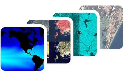
90+ petabytes of analysis-ready geospatial data
The Earth Engine catalog is one of the largest publicly available data catalogs, with 90+ petabytes of analysis-ready satellite imagery and 1,000+ curated geospatial datasets. It includes 50+ years of historical imagery, updated and expanded daily, at resolutions as fine as one meter per pixel. Examples include Landsat, MODIS and Sentinel, the National Agriculture Imagery Program (NAIP), climate and weather data, geophysical data, including terrain, land cover, and cropland data.
The catalog offers data on the entire planet, allowing users to understand earth changes relevant to their sustainability goals.
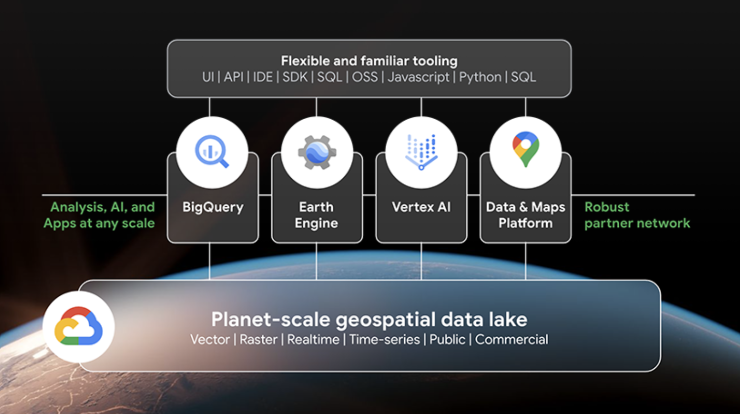
Powerful computation platform at scale
Google Cloud empowers everyone to run large-scale parallel processing using many thousands of computers. Combining Earth Engine’s data catalog with Google Cloud’s computational capability and data analytics tools, makes Earth Engine a revolutionary platform to analyze and visualize earth data at scale.
Faster access, processing, and analysis of data means faster innovations, informed decisions, and viable solutions. The U.S. Forest Service, for example, manages 193 million acres of U.S. forest lands, reducing the time to complete mission critical tasks from months to hours with Earth Engine’s superior data catalog and computational scalability.
Code Editor
The Earth Engine Code Editor is a web-based coding environment designed to make developing complex geospatial workflows fast and easy with the following elements:
- JavaScript Code Editor
- Map display for visualizing geospatial datasets
- API reference documentation (Docs tab)
- Git-based Script Manager (Scripts tab)
- Console output (Console tab)
- Task Manager (Tasks tab) to handle long-running queries
- Interactive map query (Inspector tab)
- Search of the data archive or saved scripts
- Geometry drawing tools
Earth Engine Python API and Colab experience (geemap)
Earth Engine Python API allows users to make use of Python tools for machine learning and analysis, including those for geospatial workloads, like Cloud Optimized GeoTiffs and GeoPandas.
The geemap Python library is supported in Earth Engine, for visual workflows in Python, like panning, zooming, and drawing map polygons for zonal statistics.
Xarray, a well-known Python package, enables working with multidimensional arrays. Xee, its Earth Engine integration, lets users work with Earth Engine ImageCollections as Xarray datasets.

Earth Engine Machine Learning
Earth Engine has built-in capabilities to allow users to train and use ML models for common scenarios with easy-to-use APIs. For instance, you can use a random forest algorithm to classify land in an area of interest. If you'd prefer to use a Deep Neural Network, you can also train a TensorFlow or PyTorch model, deploy it to Gemini Enterprise Agent Platform and get predictions from within the Earth Engine Code Editor.
Import your own data for analysis with the Earth Engine data catalog
Users can import their own data (images and tables) and combine them with datasets from the Earth Engine data catalog to derive insights. Using the Asset Manager in Code Editor or command line interface (CLI), georeferenced raster datasets in GeoTIFF or TFRecord format and tabular data in Shapefile or CSV format can be imported to build data products, create models, and develop unique solutions to accelerate sustainability efforts.

Export your results for integration into other systems
If you're training a TensorFlow model or want to run hydrology simulations outside Earth Engine you might want to get data out of Earth Engine into another system. The Earth Engine export API does the heavy lifting and our data extraction methods help solve scaling issues and work with frameworks like Apache Beam, Spark, or Dask. Our Python client library comes bundled with client-side logic to convert between Earth Engine objects and NumPy, Pandas, and GeoPandas types.

Earth Engine Apps
For code-free, interactive visualizations, Earth Engine Apps are dynamic, shareable user interfaces for Earth Engine analyses.
With Earth Engine Apps, developers can use simple UI elements to leverage Earth Engine's data catalog and analytical power, allowing stakeholders to interact with their data and delivering insights into the hands of decision-makers.
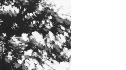
Cloud Score+
Cloud Score+ solves the issue of cloud cover in Sentinel-2 satellite data. It is a comprehensive QA score, powered by deep learning, which provides a per-pixel “usability” score to mask or weight observations based on overall quality.
Dynamic World
Dynamic World is a global, near-real-time Land Cover dataset at a 10m resolution, powered by machine learning. It gives unprecedented detail about land use and helps make accurate predictions and effective sustainability plans.
How It Works
Reference analysis-ready datasets in Earth Engine's petabyte-scale data catalog. Run raster and vector data analysis in parallel on thousands of machines. Iteratively test and tweak results in Code Editor, by writing custom Python code with Earth Engine's client library or by extracting results from a model hosted in Gemini Enterprise Agent Platform. Share results in BigQuery or in Earth Engine Apps.
Reference analysis-ready datasets in Earth Engine's petabyte-scale data catalog. Run raster and vector data analysis in parallel on thousands of machines. Iteratively test and tweak results in Code Editor, by writing custom Python code with Earth Engine's client library or by extracting results from a model hosted in Gemini Enterprise Agent Platform. Share results in BigQuery or in Earth Engine Apps.
Sustainable sourcing
Enable global supply chain transparency and traceability
Enable global supply chain transparency and traceability
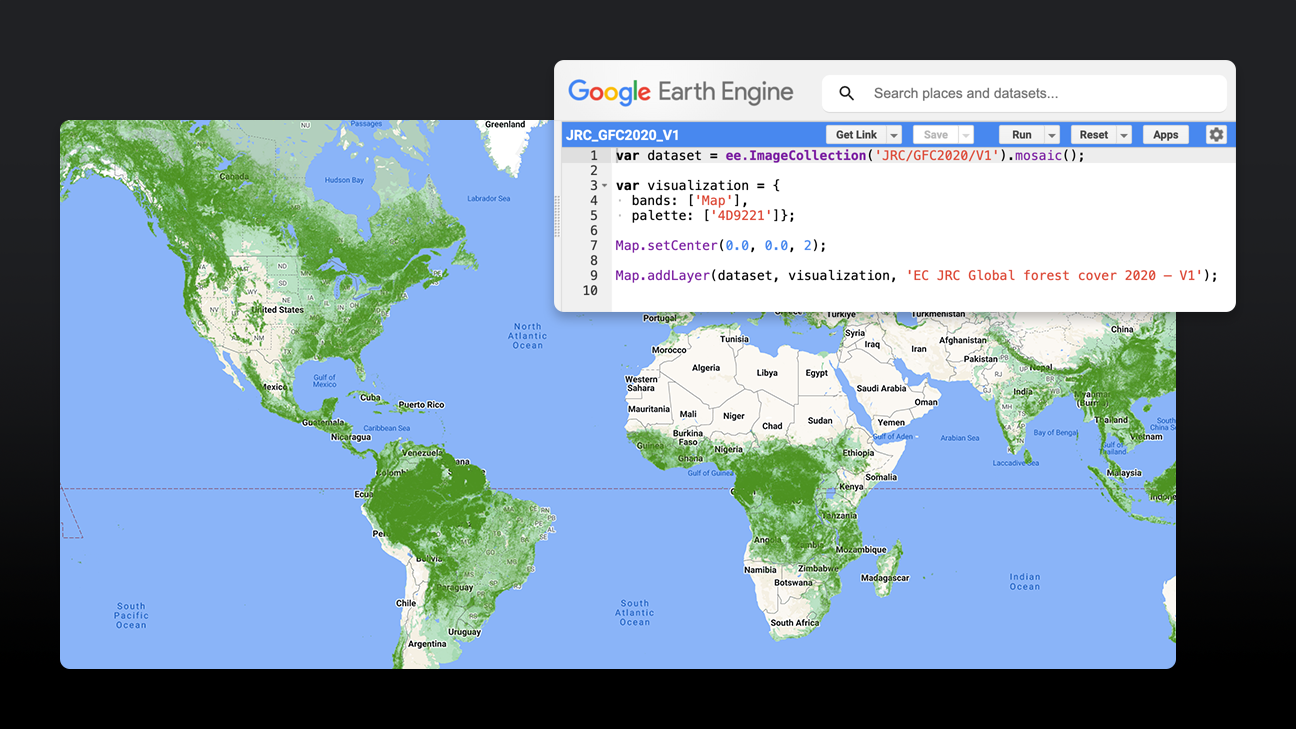
Sustainable supply chains are business critical. Earth Engine helps businesses analyze land cover and use at sourcing sites to highlight deforestation risk in their supply chains. The EC JRC global map of forest cover for 2020 is useful for this. A spatially explicit representation of forest presence/absence in 2020 at 10m resolution, this dataset corresponds to the EU Deforestation Regulation (EUDR), which will require companies to provide statements affirming goods sold or produced in the EU were not grown on land deforested after December 31, 2020.
TraceMark: First-mile driven traceability for raw materials
TraceMark: First-mile driven traceability for raw materials
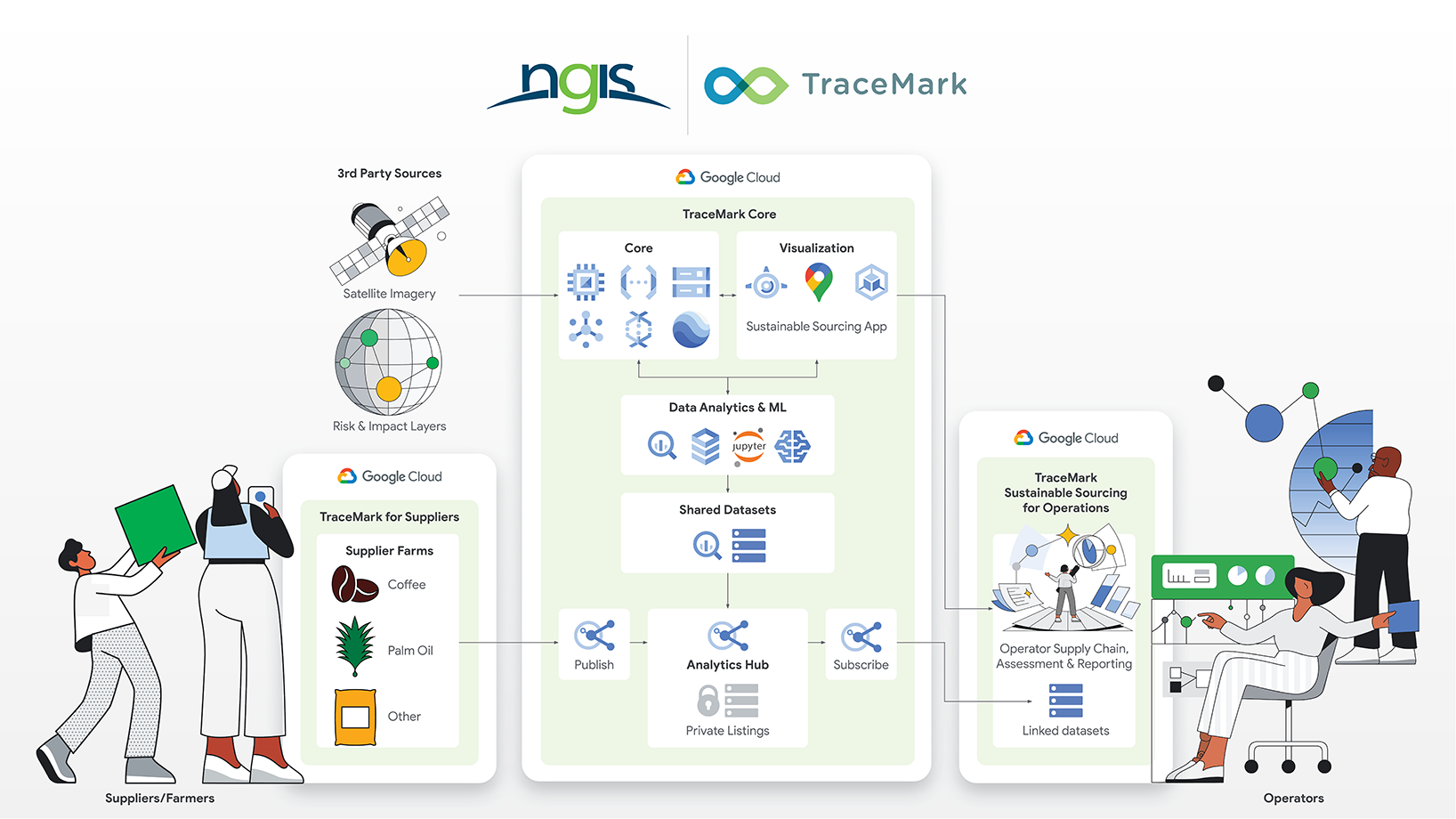
TraceMark, built by Google Cloud Advantage partner NGIS, uses Earth Engine to map the sourcing of raw materials and potential risk through global supply chains, providing comprehensive first-mile monitoring and end-to-end traceability insights.
TraceMark leverages leading frameworks and provides EU Deforestation Regulation (EUDR)-specific capabilities for risk mitigation and due diligence, including data exchange and engagement with suppliers, and sustainability metrics for reporting.
TraceMark provides multi commodity capability to address all EUDR-impacted products, including palm, coffee, cocoa, soy, and paper.

Tutorials, quickstarts, & labs
Enable global supply chain transparency and traceability
Enable global supply chain transparency and traceability
Sustainable supply chains are business critical. Earth Engine helps businesses analyze land cover and use at sourcing sites to highlight deforestation risk in their supply chains. The EC JRC global map of forest cover for 2020 is useful for this. A spatially explicit representation of forest presence/absence in 2020 at 10m resolution, this dataset corresponds to the EU Deforestation Regulation (EUDR), which will require companies to provide statements affirming goods sold or produced in the EU were not grown on land deforested after December 31, 2020.
Partners & integrations
TraceMark: First-mile driven traceability for raw materials
TraceMark: First-mile driven traceability for raw materials
TraceMark, built by Google Cloud Advantage partner NGIS, uses Earth Engine to map the sourcing of raw materials and potential risk through global supply chains, providing comprehensive first-mile monitoring and end-to-end traceability insights.
TraceMark leverages leading frameworks and provides EU Deforestation Regulation (EUDR)-specific capabilities for risk mitigation and due diligence, including data exchange and engagement with suppliers, and sustainability metrics for reporting.
TraceMark provides multi commodity capability to address all EUDR-impacted products, including palm, coffee, cocoa, soy, and paper.
Climate risk
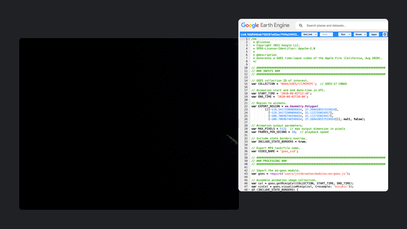
Safeguard assets against extreme climate risks, such as fires
Safeguard assets against extreme climate risks, such as fires
Disaster response agencies require precise and timely data and insights in order to monitor fires, evaluate risks, and protect assets. Datasets in Earth Engine, such as GOES MCMIP (imagery), GOES FDC (fire detection), and FIRMS (Fire Information for Resource Management System), can be analyzed to monitor fires, as well as facilitate fire modeling and risk management. Analyzing this data helps improve the efficiency of response and disaster recovery efforts, making them more effective.
Cloud partners with climate risk expertise
Cloud partners with climate risk expertise
Climate Engine’s SpatiaFi solution links asset and geospatial data to support regulatory reporting, climate risk reductions, and sustainable finance.
CARTO’s cloud native Location Intelligence platform helps organizations analyze climate impacts, optimize processes, and predict outcomes.
Deloitte is building new geospatial planning solutions using Earth Engine and Google Cloud’s GenAI to help clients build sustainable communities and infrastructure, enhance operational resilience, and prepare for climate change impacts.
SIG, for 25 years, has honed expertise in mapping environmental change, specializing in evaluating risks like fire, drought, flood, agricultural disruptions, and health threats.


Tutorials, quickstarts, & labs
Safeguard assets against extreme climate risks, such as fires
Safeguard assets against extreme climate risks, such as fires
Disaster response agencies require precise and timely data and insights in order to monitor fires, evaluate risks, and protect assets. Datasets in Earth Engine, such as GOES MCMIP (imagery), GOES FDC (fire detection), and FIRMS (Fire Information for Resource Management System), can be analyzed to monitor fires, as well as facilitate fire modeling and risk management. Analyzing this data helps improve the efficiency of response and disaster recovery efforts, making them more effective.
Partners & integrations
Cloud partners with climate risk expertise
Cloud partners with climate risk expertise
Climate Engine’s SpatiaFi solution links asset and geospatial data to support regulatory reporting, climate risk reductions, and sustainable finance.
CARTO’s cloud native Location Intelligence platform helps organizations analyze climate impacts, optimize processes, and predict outcomes.
Deloitte is building new geospatial planning solutions using Earth Engine and Google Cloud’s GenAI to help clients build sustainable communities and infrastructure, enhance operational resilience, and prepare for climate change impacts.
SIG, for 25 years, has honed expertise in mapping environmental change, specializing in evaluating risks like fire, drought, flood, agricultural disruptions, and health threats.
Protect natural resources
Sustainable management and conservation of natural resources
Sustainable management and conservation of natural resources
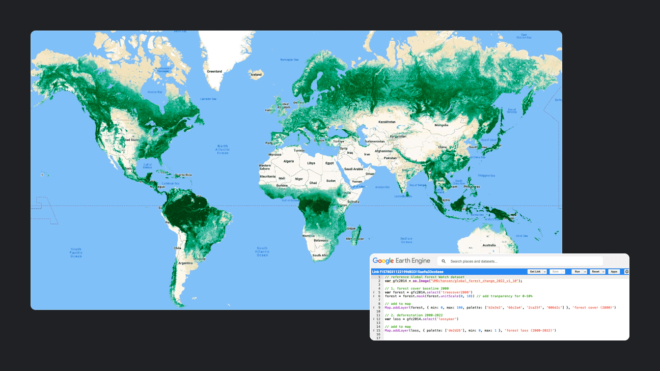
Leveraging the Hansen global forest change dataset in Earth Engine, users can carry out analysis of forest change, quantifying forest change over time and charting yearly forest loss. Using the Forest Monitoring for Action (FORMA, Hammer et al. 2009) data from Global Forest Watch, users can filter by dates and configure alerts within specific areas of interest.
Cloud partners with protecting natural resources expertise
Cloud partners with protecting natural resources expertise
With 25 years of expertise, SIG excels in protecting natural resources through comprehensive mapping of land cover and use change, real-time change detection, restoration potential assessment, and biodiversity monitoring, ensuring effective environmental conservation strategies.

Tutorials, quickstarts, & labs
Sustainable management and conservation of natural resources
Sustainable management and conservation of natural resources
Leveraging the Hansen global forest change dataset in Earth Engine, users can carry out analysis of forest change, quantifying forest change over time and charting yearly forest loss. Using the Forest Monitoring for Action (FORMA, Hammer et al. 2009) data from Global Forest Watch, users can filter by dates and configure alerts within specific areas of interest.
Partners & integrations
Cloud partners with protecting natural resources expertise
Cloud partners with protecting natural resources expertise
With 25 years of expertise, SIG excels in protecting natural resources through comprehensive mapping of land cover and use change, real-time change detection, restoration potential assessment, and biodiversity monitoring, ensuring effective environmental conservation strategies.
Agriculture
Build toward a higher yield, lower impact food system with agriculture insights
Build toward a higher yield, lower impact food system with agriculture insights
Earth Engine can be used to surface insights into crop health, water consumption, and seasonal patterns of productivity. MOD13A2.061 Terra Vegetation Indices 16-Day Global 1km can be leveraged to generate a time-series animation representing 20-year median vegetation productivity. For more informed decision-making, users can analyze datasets like MODIS land surface temperature data or ERA5 composites to calculate Growing Degree Days (GDDs) and then apply machine learning in Gemini Enterprise Agent Platform to predict when crops will reach maturity or to calculate optimal timing for pest management.

Cloud partners with agriculture expertise
Cloud partners with agriculture expertise
- Woolpert: A partner and leading provider of state-of-the-art geospatial services. Woolpert has helped several organizations in both the public and private sector build their Earth Engine stack for geospatial intelligence, including agricultural analytics and other land management applications.
- NGIS: A dedicated geospatial company and Google Partner has extensive experience in partnering with leading agriculture organizations to implement Earth Engine. Using Earth Engine, the NGIS team has developed solutions across agricultural nutrition, protection, production, and analytics to operationalize petabytes of satellite imagery to deliver new insights and products.
- Spatial Informatics Group (SIG): It has been providing environmental decision support tools for 25 years. Expertise include: vegetation cover types identification through spectral discrimination; phenology and seasonal vegetation change analysis; crop monitoring and yield estimation.


Tutorials, quickstarts, & labs
Build toward a higher yield, lower impact food system with agriculture insights
Build toward a higher yield, lower impact food system with agriculture insights
Earth Engine can be used to surface insights into crop health, water consumption, and seasonal patterns of productivity. MOD13A2.061 Terra Vegetation Indices 16-Day Global 1km can be leveraged to generate a time-series animation representing 20-year median vegetation productivity. For more informed decision-making, users can analyze datasets like MODIS land surface temperature data or ERA5 composites to calculate Growing Degree Days (GDDs) and then apply machine learning in Gemini Enterprise Agent Platform to predict when crops will reach maturity or to calculate optimal timing for pest management.
Partners & integrations
Cloud partners with agriculture expertise
Cloud partners with agriculture expertise
- Woolpert: A partner and leading provider of state-of-the-art geospatial services. Woolpert has helped several organizations in both the public and private sector build their Earth Engine stack for geospatial intelligence, including agricultural analytics and other land management applications.
- NGIS: A dedicated geospatial company and Google Partner has extensive experience in partnering with leading agriculture organizations to implement Earth Engine. Using Earth Engine, the NGIS team has developed solutions across agricultural nutrition, protection, production, and analytics to operationalize petabytes of satellite imagery to deliver new insights and products.
- Spatial Informatics Group (SIG): It has been providing environmental decision support tools for 25 years. Expertise include: vegetation cover types identification through spectral discrimination; phenology and seasonal vegetation change analysis; crop monitoring and yield estimation.
Environmental impact
Gather environmental insights; detect and monitor change
Gather environmental insights; detect and monitor change
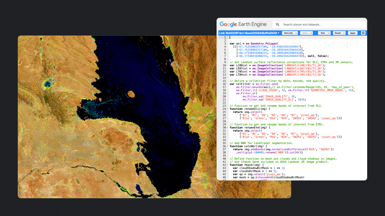
For public sector organizations and companies seeking to tackle emissions and derive insights into the drivers of degradation and effectiveness of interventions, custom analysis can be applied to Earth Engine datasets to detect environmental impacts over time. For example, using annual segmented Landsat time series data from 1984-2019 to depict lake drying in Bolivia, or combining methane data with other datasets—like land cover, forests, water, ecosystems, regional borders, and more—to track methane emissions in a given area over time.
Cloud partners with expertise in environmental impact
Cloud partners with expertise in environmental impact
Deloitte’s methane emissions quantification solution—built on Google Earth Engine—is a geospatial artificial intelligence (AI) and machine learning (ML) analytics tool designed for organizations to monitor, quantify, and prioritize closure of problematic orphan wells to reduce methane emissions, protect water and air, and mitigate safety risks to improve human and environmental health.


Tutorials, quickstarts, & labs
Gather environmental insights; detect and monitor change
Gather environmental insights; detect and monitor change
For public sector organizations and companies seeking to tackle emissions and derive insights into the drivers of degradation and effectiveness of interventions, custom analysis can be applied to Earth Engine datasets to detect environmental impacts over time. For example, using annual segmented Landsat time series data from 1984-2019 to depict lake drying in Bolivia, or combining methane data with other datasets—like land cover, forests, water, ecosystems, regional borders, and more—to track methane emissions in a given area over time.
Partners & integrations
Cloud partners with expertise in environmental impact
Cloud partners with expertise in environmental impact
Deloitte’s methane emissions quantification solution—built on Google Earth Engine—is a geospatial artificial intelligence (AI) and machine learning (ML) analytics tool designed for organizations to monitor, quantify, and prioritize closure of problematic orphan wells to reduce methane emissions, protect water and air, and mitigate safety risks to improve human and environmental health.
Pricing
| How Earth Engine pricing works | Earth Engine pricing is based on usage of Earth Engine resources (compute units and storage) and a monthly platform fee. | |
|---|---|---|
| Plans and usage | Description | Price (USD) |
Basic | Best for organizations with small teams and small workloads. Includes 2 developer seats, 20 concurrent high-volume API requests, and up to 8 concurrent batch export tasks. | $500 per month |
Professional | Best for organizations with moderate-sized teams and predictable, time-sensitive, large-scale workloads. Includes 5 developer seats, 500 concurrent high-volume API requests, and up to 20 concurrent batch export tasks. | $2,000 per month |
Premium | Best for larger teams with business critical, time-sensitive, large-scale workloads. Premium plan allocations can be customized. Please contact your Google Cloud sales representative for more information. | Contact us |
Compute (analysis) | Earth Engine Compute Units (EECUs) consist of Earth Engine managed workers used to execute tasks. Compute pricing is charged by EECU-hour and rates vary based on the processing environment you use. | |
Compute (Online and Batch) | $0.40 per EECU-hour | |
Storage | $0.026 per GB-month | |
Learn more about Earth Engine pricing. View all pricing details
How Earth Engine pricing works
Earth Engine pricing is based on usage of Earth Engine resources (compute units and storage) and a monthly platform fee.
Basic
Best for organizations with small teams and small workloads. Includes 2 developer seats, 20 concurrent high-volume API requests, and up to 8 concurrent batch export tasks.
$500
per month
Professional
Best for organizations with moderate-sized teams and predictable, time-sensitive, large-scale workloads. Includes 5 developer seats, 500 concurrent high-volume API requests, and up to 20 concurrent batch export tasks.
$2,000
per month
Premium
Best for larger teams with business critical, time-sensitive, large-scale workloads. Premium plan allocations can be customized. Please contact your Google Cloud sales representative for more information.
Contact us
Compute (analysis)
Earth Engine Compute Units (EECUs) consist of Earth Engine managed workers used to execute tasks. Compute pricing is charged by EECU-hour and rates vary based on the processing environment you use.
Compute (Online and Batch)
$0.40
per EECU-hour
Storage
$0.026
per GB-month
Learn more about Earth Engine pricing. View all pricing details
Business Case
Explore how enterprises and public sector organizations are leveraging Earth Engine

Regrow Ag is accelerating the transition to sustainable food and fiber production
John Shriver, Director of Data Science, Regrow Ag
"Our ultimate mission is to illuminate and accelerate the world’s transition to sustainable food and fiber production. We believe advancing regenerative agriculture can bring resilience to business supply chains. Working with data specialists at Google and platforms such as Google Cloud and Google Earth Engine is key to achieving this goal."


Partners & Integration
Work with a partner that has deep Earth Engine expertise


Earth Engine Initiative partners
Earth Engine partners with geospatial expertise and scalable solutions, enhance Earth Engine's capabilities and help organizations mitigate impact, protect natural resources, and build a sustainable future.