Insuring the “uninsurable” with AI geospatial models
Ingests data 80% faster with Earth Engine’s pre-processing for weather, climate, and vegetation data
Minimizes IT overhead by offloading cloud computing research needs to Colab notebooks
Improved modeling accuracy and accelerated software development using Earth Engine’s curated data library
Five-minute quote-to-buy underwriting workflow powered by Google Maps Platform
Using Google Earth Engine and AI-driven geospatial modeling to accurately predict wildfire risk enables Delos to offer affordable insurance to California homeowners deemed uninsurable by other carriers.
Using Google Earth Engine and AI-driven geospatial modeling to accurately predict wildfire risk enables Delos to offer affordable insurance to California homeowners deemed uninsurable by other carriers.
Predicting wildfires from outer space
If Kevin Stein or Shanna McIntyre says something isn’t rocket science, well, they’re in a position to know. Both co-founders of Delos Insurance trained as aerospace engineers, working for large space systems companies before founding a startup whose smallsat spacecraft enabled orbit-to-ground communication.
Then they decided to come down to earth to face down a decidedly Terran peril.
“Climate change is increasing the frequency and severity of wildfires across the globe, and especially in California,” explains Stein, Delos’s CEO. “As Californians, we wanted to use our aerospace backgrounds to predict wildfires more accurately and reduce the risk they pose to people, property, and the environment.”
Wildfire behavior models rely on accurate fuel and weather data, which are challenging to generate. Earth Engine is uniquely capable of performing those complex calculations
David Saah
Founding Principal and Managing Partner, Spatial Informatics Group
They soon realized that insurance — an industry literally invested in mitigating risk — was the best way to foster a safer built environment and protect society from the financial and emotional devastation of wildfires.
Meanwhile, the scientists at Spatial Informatics Group (SIG), who’ve spent years applying AI to geospatial data to model environmental catastrophes as well as climate change, were coming to a similar conclusion. A member of the Google AI Initiative for Wildfire Management, SIG combines Earth Engine’s computational platform with a multitude of data sources, including AlphaEarth Foundations, a Google DeepMind AI model that unifies petabytes of earth observation data that can then be more easily processed for decision-making.
“Our climate models allow us to understand future wildfire risk,” says David Saah, SIG founding principal and managing partner, “but information alone doesn’t create change.” A partnership between the two companies is now aligning science and technology with the demands of the fire insurance market.
Improving access to insurance through accurate data modeling
The growing incidence of wildfires means California homeowners can pay exorbitant premiums for homeowners insurance — if they’re able to purchase it at all. And large general insurance companies have a hit-or-miss strategy for assessing fire risk, which drives up the price of policies or leads them to exit the market.
“At Delos, we’ve integrated wildfire behavior modeling into every level of the company, from risk assessment to the pricing of our homeowners insurance policies,” Stein explains. “This allows us to adapt quickly as wildfire peril evolves.”
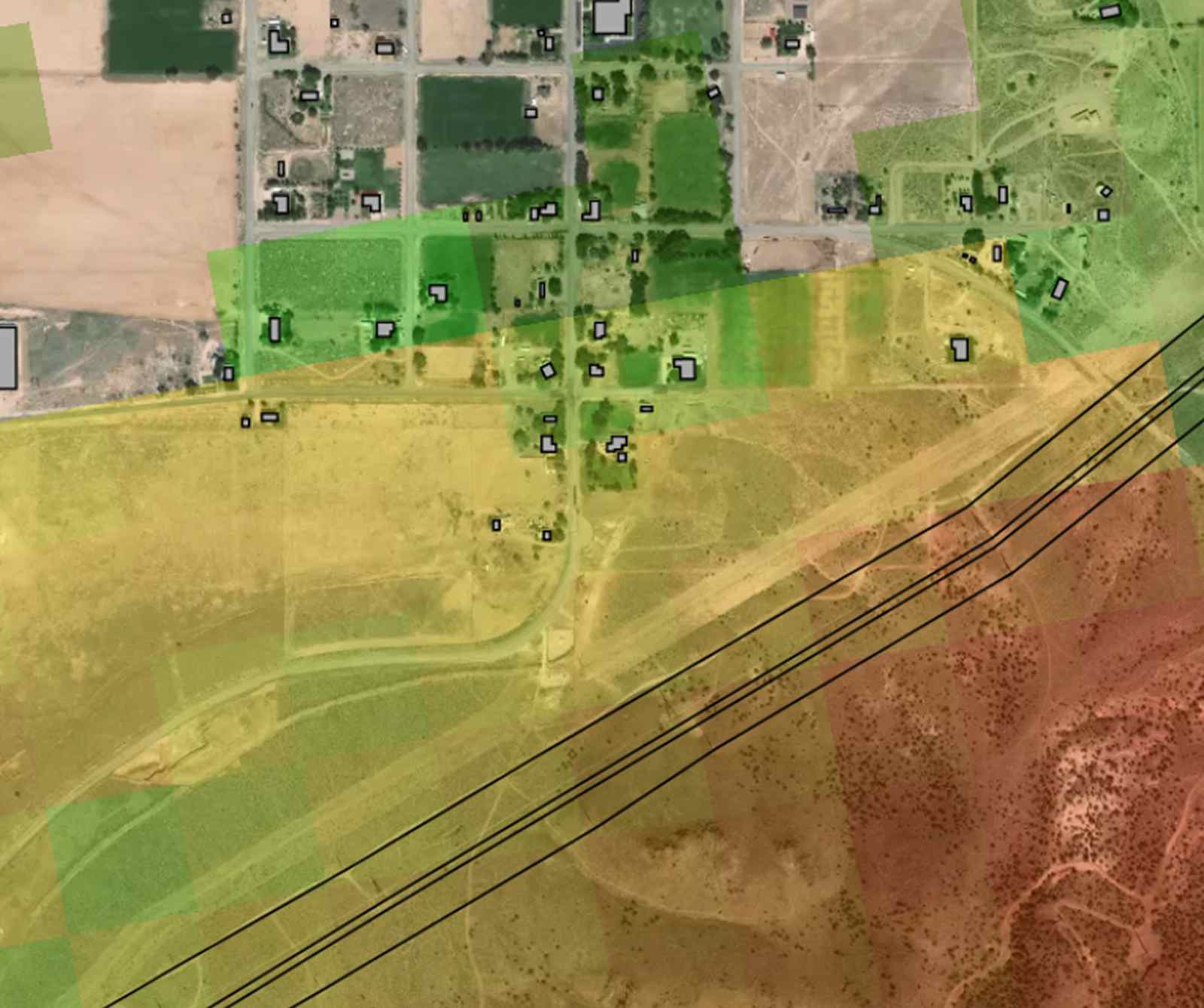
By combining Earth Engine data with advanced AI, machine learning, and deep learning analytics, SIG and Delos have developed models to accurately predict how climate- and weather-related factors like drought, wind, landscape, vegetation, and precipitation cycles contribute to fire type, intensity, and location. “Wildfire behavior models rely on accurate fuel and weather data, which are challenging to generate,” adds Saah. “Earth Engine is uniquely capable of performing those complex calculations.”
Delos’s software, powered by Google Earth Engine, uses that data to identify which areas deemed uninsurable by other companies are actually at a lower risk of wildfire, and offer affordable insurance policies to homeowners in those areas. They also advise other homeowners how to reduce the risk of wildfire damage through hardening measures such as non-combustible roofing and fire-resistant landscaping so they’ll qualify for insurance.
Google is the only company integrating AI-driven geospatial technologies into essential cloud services, which allows our developers to work more efficiently and provides us with a major competitive advantage
Kevin Stein
Co-founder and CEO, Delos Insurance
Accelerated data processing leads to accelerated product development
Integrating raw weather data into a geographic information system (GIS) can be a time-consuming, error-prone process for analysts, who must download data from a multitude of providers, standardize the disparate data formats, and then map the data points to projection systems.
“The Google Earth Engine data catalog offers an easily accessible repository of uniformly formatted landscape and weather data, eliminating the burden of manual data cleansing and ensuring data consistency throughout the analytical and development pipeline,” notes Andrew Notohamiprodjo, head of data science at Delos. “Using Google Earth Engine for risk modeling and pre-processing has reduced data preparation time by 80% compared to outsourcing, and the curated data library has significantly accelerated research and product development.”
To produce the risk models that underlie Delos’s underwriting workflows, this data is run through scripts written using Google Colab notebooks, a platform that allows developers to write and execute code directly in their web browser. It then flows into pipelines built on the Vertex AI Platform for model training and deployment. “Colab enables our scientists to easily access and provision compute resources and add memory or processing power with a few clicks,” Notohamiprodjo continues. “This has significantly accelerated our development process while keeping IT overhead low.”
“Google is the only company integrating AI-driven geospatial technologies into essential cloud services,” Saah adds. “That allows our developers to work more efficiently and provides us with a major competitive advantage.”
Investing in Google’s unified technology ecosystem has greatly accelerated product development, improved connectivity, and boosted efficiency across our entire organization
Kevin Stein
Co-founder and CEO, Delos Insurance
The accuracy of Delos’s models provide the certainty to offer insurance at prices significantly lower than the market standard. It also enables them to offer insurance to homeowners across 83% of the state — a coverage area nearly twice as big as most larger insurers.
Delos’s Earth Engine–driven wildfire behavior modeling is so accurate that the company registered zero losses after Los Angeles’s Palisades wildfire in January 2025. “Most importantly, accurate modeling enables us to remain a stable insurance marketplace in California, from which many other insurers have pulled out,” Stein states proudly, adding that Delos currently insures over 30,000 properties statewide.
Quote-to-buy insurance in five minutes with Google Maps Platform
Delos operates as a managing general agent, selling policies through insurance agents rather than directly to consumers. To provide those agents with a seamless user experience, Delos built an underwriting portal that incorporates Google Maps Platform and the Places API. The API’s autocomplete feature ensures accurate address information for risk prediction and policy underwriting.
Traditionally, agents have submitted physical forms or emailed underwriters, who then manually reviewed property details; misspelled or mistyped addresses often led to underwriting declinations or delays. The Places API autocompletes addresses, ensuring accuracy and making agents’ lives easier. “The decision to use Google Maps Platform was an easy one,” notes Notohamiprodjo. “Google Maps is ubiquitous, and everyone knows how to use it — if you need to find an address, you just Google it.”
The Delos platform then pings Delos’s wildfire model alongside property data such as a home’s age and size, enabling Delos to generate an online quote in real time without manual intervention. Traditionally, underwriting homes can take specialty insurers anywhere from two days to two weeks; Delos reduces that time to under five minutes, allowing insurance agents to adjust coverage and write policies immediately, and helping consumers secure coverage they need faster.
As a managing general agent, Delos works with numerous partners, from large carriers and reinsurance companies to independent mom-and-pop insurance agents in small towns. To keep its partners informed, Delos provides dashboards built with Looker Studio that offer insights into product performance and risk assessment. Delos even uses Google Workspace for back-office operations and collaboration.
“Investing in Google’s unified technology ecosystem has greatly accelerated product development, improved connectivity, and boosted efficiency across our entire organization,” reports Stein.
It takes community to protect communities
Stein and Notohamiprodjo describe their collaboration with Google as consistently smooth and efficient. “Onboarding to Earth Engine was very quick, and as the Delos platform evolved, integrating services like Google Maps and Looker Studio was straightforward,” recalls Notohamiprodjo. “The teams at Google Earth Engine and Google Maps foster community, providing essential technological and scientific expertise and incorporating our insights and feedback into the Google ecosystem.”
This continuous feedback loop and commitment to community-building is integral to Delos’s participation in initiatives like the AI Collaborative for Wildfires. The project brings together over 15 nonprofits, academic institutions, government agencies, and companies to use AI to improve wildfire management and resilience — the goal that inspired Stein to found Delos. The company also contributes to X, The Moonshot Factory, a Google initiative dedicated to finding technology solutions to global problems like climate change.
“Google Earth Engine data and Google Maps location intelligence are integral to the Delos platform,” Stein concludes. “They’re what enable us to provide a fast, automated quote-to-bid workflow for our customers and affordable wildfire insurance to consumers when other insurance markets cannot.”
All it takes is a little rocket science.
Delos uses AI-driven geospatial risk modeling to provide affordable wildfire insurance to more than 30,000 California homeowners living in high-risk areas.
Industry: Insurance
Location: United States
Products: Google Maps Platform, Places API, Google Earth Engine, Google Cloud, Colab, Looker Studio
About Google Cloud partner — Spatial Informatics Group
SIG provides geospatial analysis and technology solutions for natural hazard risk reduction, climate change adaptation, and environmental mapping to help develop a green economy and ensure a sustainable future.