Delivers accurate emergency response ETAs with Google Maps Platform
Cuts cost per dispatch by more than 50%
Delivers projected annual savings of approximately $56,000
Processes emergency signals every 45 seconds
AURA enriched its safety platform with Google Maps Platform to ensure accurate ETA calculations and reliable global scaling, cutting dispatch costs by over 50%.
AURA enriched its safety platform with Google Maps Platform to ensure accurate ETA calculations and reliable global scaling, cutting dispatch costs by over 50%.
Building a reliable, scalable global safety network with Google Maps Platform
In an emergency, every second counts. Yet many conventional response networks still rely on localized control centers and manual radio dispatching, which can leave individuals waiting anxiously without a clear idea of when assistance will show up.
South Africa-based safety technology platform AURA aims to address this problem, with a mission to create a safer world by making emergency response faster, transparent, and accessible everywhere. To do so, AURA accepts emergency signals from sources such as mobile apps, internet-connected panic buttons, wearables, and ride-hailing services, and directly connects people in need to the closest verified private security or medical responder.
To support our expansion into global markets, we needed a map provider with accurate, reliable real-time traffic data and global scale. Google Maps Platform gives us the data quality, user familiarity, and global reach we need to meet our customers’ expectations.
Grant Macwilliam
CTO, AURA
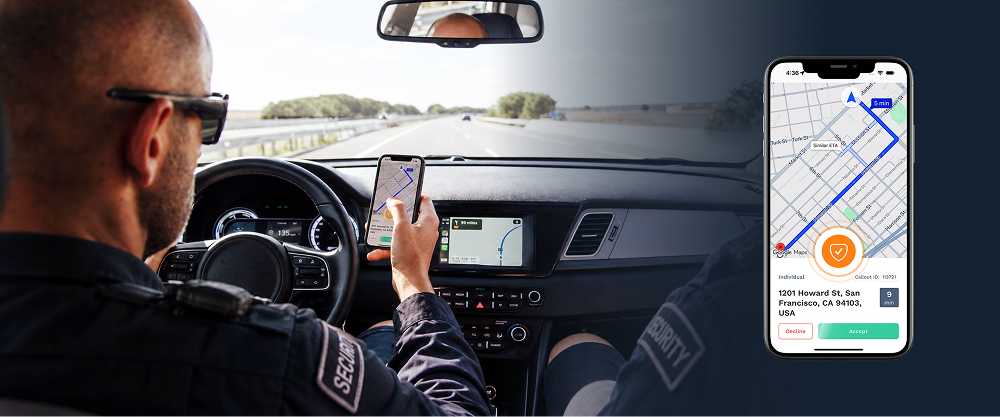
Delivering rapid response times requires highly accurate location data. Previously, AURA relied on a range of mapping providers across different regions. However, these tools frequently failed to generate accurate estimated times of arrival (ETAs) based on live traffic conditions and road closures. Inaccurate ETAs created unnecessary anxiety for users in distress and threatened to damage trust in the platform. Furthermore, inconsistent mapping experiences across different areas led some field workers to bypass the company app entirely, opting to use Google Maps on their personal devices to find their way.
As AURA expanded its operations into the UK and the U.S., it needed to be able to provide consistent, real-time traffic data worldwide. Working alongside location intelligence partner Localyse, AURA selected Google Maps Platform as its geospatial data foundation, successfully navigating the complex compliance requirements of the emergency response sector. Aura’s strategic Location Intelligence partner, Localyse, played a pivotal role in bridging this gap. Working closely with Google’s product and compliance teams, Localyse ensured all safety and operational requirements were met to pave the way for the agreement.
“To support our expansion into global markets, we needed a map provider with accurate, reliable, real-time traffic data and global scale,” explains Grant Macwilliam, CTO at AURA. “Google Maps Platform gives us the data quality, user familiarity, and global reach we need to meet our customers’ expectations.”
Maintaining a native bridge on our previous provider meant double the development effort across different mobile platforms. Adopting out-of-the-box software kits from Google Maps Platform simplifies development, freeing our engineering team to focus on building new safety features.
Grant Macwilliam
CTO, AURA
Streamlining field dispatches and operations with Navigation SDK and Places API
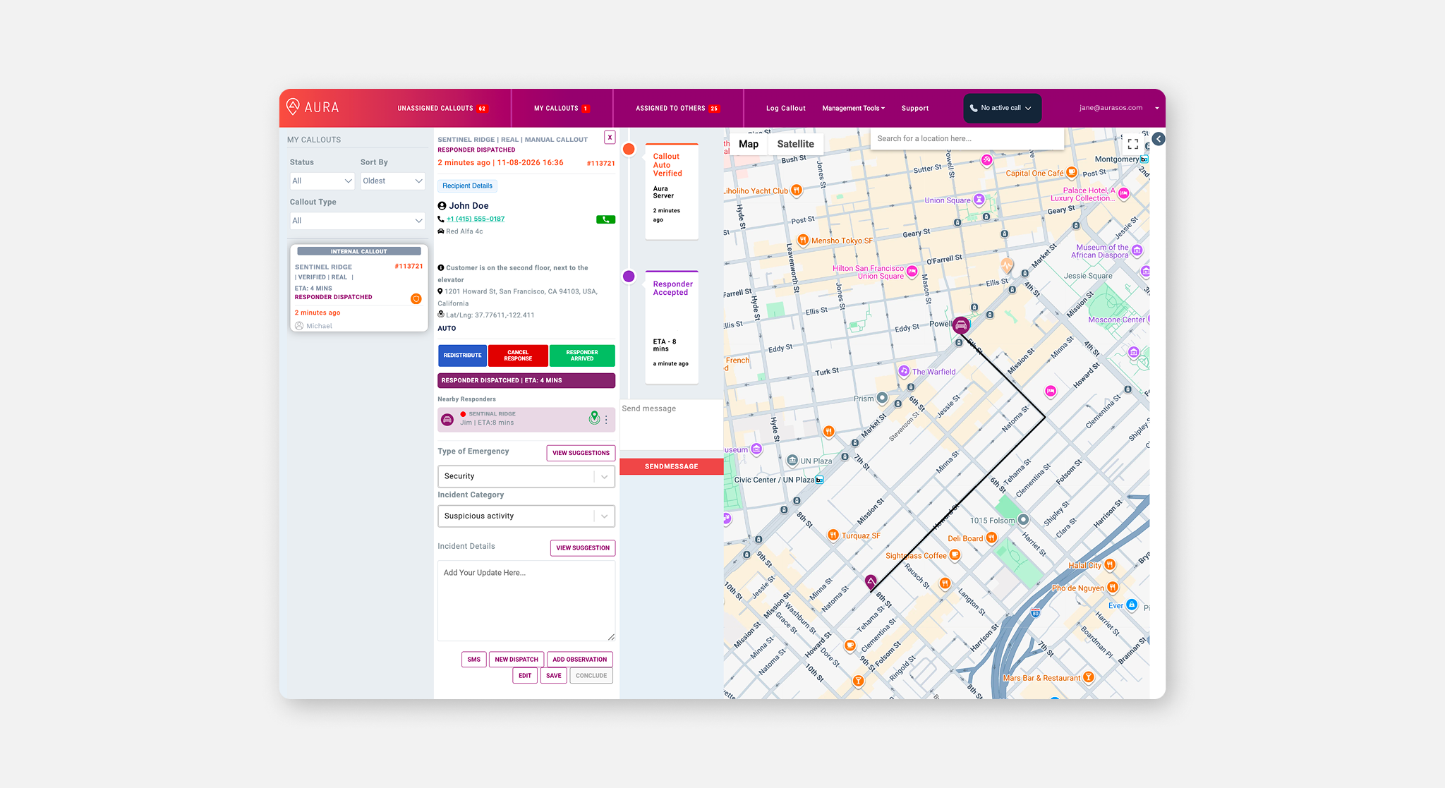
AURA incorporated Google Maps Platform into every step of its dispatch workflow. For field workers, the company integrated the Navigation SDK straight into its responder mobile application. This provides personnel with in-app turn-by-turn driving instructions, lane guidance, and walking routes, helping them reach the scene as quickly as possible. The familiar interface also simplifies onboarding for new responders.
When someone presses a panic button, they need to be able to trust that help is on its way. With Google Maps Platform, we have the accuracy and scale to fulfill that promise for people everywhere.
Grant Macwilliam
CTO, AURA
To assign incidents, AURA’s automated dispatch engine uses Google Maps Platform routing and ETA calculations to monitor nearby eligible personnel, such as advanced life support paramedics. By automatically calculating driving times and distances, the system quickly matches the closest available responder to an emergency, providing the caller with an accurate ETA for immediate reassurance.
To ensure location accuracy before an incident even occurs, AURA uses the Places API and Autocomplete to help customers register fixed properties with precise addresses. Inside the 24/7 control room, operators monitor active dispatches using dynamic and static maps.
Controllers can view property entrances and building layouts using satellite imagery, and use reverse geocoding to translate coordinates into readable addresses to safely guide responders.
To maintain transparency with business clients like banks and ride-hailing firms, AURA channels its dispatch data into BigQuery and visualizes the performance metrics using Data Studio. This allows clients to monitor incident trends and average response times. Meanwhile, AURA’s engineering team has eliminated the need to maintain custom native code across different mobile operating systems by adopting pre-built software kits.
“Maintaining a native bridge on our previous provider meant double the development effort across different mobile platforms,” explains Macwilliam. “Adopting out-of-the-box software kits from Google Maps Platform simplifies development, freeing our engineering team to focus on building new safety features.”
Scaling global protection and reducing dispatch costs with Google Maps Platform
Standardizing on Google Maps Platform yielded immediate financial and operational advantages for AURA. By consolidating multiple regional mapping services into a single provider, the company cut its cost per dispatch from $0.26 to $0.11—a reduction of more than 50%. This creates projected annual savings of approximately $56,000, which helps AURA keep its emergency response services affordable.
By integrating Google Maps Platform, AURA now processes emergency signals every 45 seconds and handles approximately 45,000 dispatches each month. The platform has managed more than 1.2 million historical incidents and is growing at 13% month-over-month, supported by a scalable global infrastructure that connects 26 partner networks worldwide.
As AURA continues its expansion across the UK, Europe, and the U.S., it plans to use the Isochrones API to visualize reachable areas based on live traffic conditions. This will allow the company to monitor service level agreements and pinpoint locations requiring additional responder coverage. With Localyse's continued support as a vital Location Intelligence partner, AURA is also exploring new capabilities such as the Destination API for precise building entrance routing to guide responders directly to property doors.
By combining smart technology with reliable navigation data, AURA is building a safer, more transparent emergency response network. “When someone presses a panic button, they need to be able to trust that help is on its way,” concludes Macwilliam. “With Google Maps Platform, we have the accuracy and scale to fulfill that promise for people everywhere."
South Africa-based safety technology platform AURA creates a safer world by making emergency response faster, transparent, and accessible everywhere. It connects people in need to the closest verified private security or medical responder.
Industry: Technology
Location: South Africa
Products: Google Maps Platform, Autocomplete, Navigation SDK, Places API, Google Cloud, BigQuery, Data Studio
About Google Cloud partner – Localyse
Localyse is a Google Maps partner specializing in location intelligence, providing technical expertise and guidance to help businesses implement reliable mapping solutions globally.