地標偵測功能可偵測圖片中常見的自然和人造結構。
地標偵測要求
設定 Google Cloud 專案和驗證
如果您尚未建立 Google Cloud 專案,請立即建立。展開這個部分即可查看操作說明。
- Sign in to your Google Cloud account. If you're new to Google Cloud, create an account to evaluate how our products perform in real-world scenarios. New customers also get $300 in free credits to run, test, and deploy workloads.
-
In the Google Cloud console, on the project selector page, select or create a Google Cloud project.
Roles required to select or create a project
- Select a project: Selecting a project doesn't require a specific IAM role—you can select any project that you've been granted a role on.
-
Create a project: To create a project, you need the Project Creator
(
roles/resourcemanager.projectCreator), which contains theresourcemanager.projects.createpermission. Learn how to grant roles.
-
Verify that billing is enabled for your Google Cloud project.
-
Enable the Vision API.
Roles required to enable APIs
To enable APIs, you need the Service Usage Admin IAM role (
roles/serviceusage.serviceUsageAdmin), which contains theserviceusage.services.enablepermission. Learn how to grant roles. -
Install the Google Cloud CLI.
-
如果您使用外部識別資訊提供者 (IdP),請先 使用聯合身分登入 gcloud CLI。
-
如要初始化 gcloud CLI,請執行下列指令:
gcloud init -
In the Google Cloud console, on the project selector page, select or create a Google Cloud project.
Roles required to select or create a project
- Select a project: Selecting a project doesn't require a specific IAM role—you can select any project that you've been granted a role on.
-
Create a project: To create a project, you need the Project Creator
(
roles/resourcemanager.projectCreator), which contains theresourcemanager.projects.createpermission. Learn how to grant roles.
-
Verify that billing is enabled for your Google Cloud project.
-
Enable the Vision API.
Roles required to enable APIs
To enable APIs, you need the Service Usage Admin IAM role (
roles/serviceusage.serviceUsageAdmin), which contains theserviceusage.services.enablepermission. Learn how to grant roles. -
Install the Google Cloud CLI.
-
如果您使用外部識別資訊提供者 (IdP),請先 使用聯合身分登入 gcloud CLI。
-
如要初始化 gcloud CLI,請執行下列指令:
gcloud init - BASE64_ENCODED_IMAGE:二進位圖片資料的 Base64 表示法 (ASCII 字串)。這個字串應類似下列字串:
/9j/4QAYRXhpZgAA...9tAVx/zDQDlGxn//2Q==
- RESULTS_INT:(選填) 要傳回的結果整數值。如果省略
"maxResults"欄位及其值,API 會傳回預設值,也就是 10 個結果。這個欄位不適用於下列特徵類型:TEXT_DETECTION、DOCUMENT_TEXT_DETECTION或CROP_HINTS。 - PROJECT_ID:您的 Google Cloud 專案 ID。
- CLOUD_STORAGE_IMAGE_URI:Cloud Storage 值區中有效圖片檔案的路徑。您必須至少擁有檔案的讀取權限。
範例:
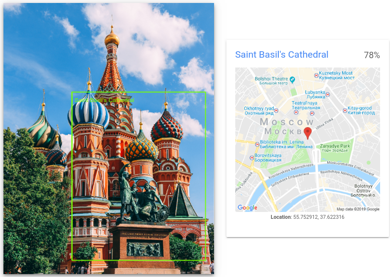
gs://cloud-samples-data/vision/landmark/st_basils.jpeg
- RESULTS_INT:(選填) 要傳回的結果整數值。如果省略
"maxResults"欄位及其值,API 會傳回預設值,也就是 10 個結果。這個欄位不適用於下列特徵類型:TEXT_DETECTION、DOCUMENT_TEXT_DETECTION或CROP_HINTS。 - PROJECT_ID:您的 Google Cloud 專案 ID。
偵測本機圖片中的地標
您可以使用 Vision API 對本機圖片檔執行特徵偵測。
如果是 REST 要求,請在要求主體中,以 base64 編碼字串的形式傳送圖片檔案內容。
如果是 gcloud 和用戶端程式庫要求,請在要求中指定本機圖片的路徑。
REST
使用任何要求資料之前,請先替換以下項目:
HTTP 方法和網址:
POST https://vision.googleapis.com/v1/images:annotate
JSON 要求主體:
{
  "requests": [
    {
      "image": {
        "content": "BASE64_ENCODED_IMAGE"
      },
      "features": [
        {
          "maxResults": RESULTS_INT,
          "type": "LANDMARK_DETECTION"
        },
      ]
    }
  ]
}
如要傳送要求,請選擇以下其中一個選項:
curl
將要求主體儲存在名為 request.json 的檔案中,然後執行下列指令:
curl -X POST \
     -H "Authorization: Bearer $(gcloud auth print-access-token)" \
     -H "x-goog-user-project: PROJECT_ID" \
     -H "Content-Type: application/json; charset=utf-8" \
     -d @request.json \
     "https://vision.googleapis.com/v1/images:annotate"
PowerShell
將要求主體儲存在名為 request.json 的檔案中,然後執行下列指令:
$cred = gcloud auth print-access-token
$headers = @{ "Authorization" = "Bearer $cred"; "x-goog-user-project" = "PROJECT_ID" }

Invoke-WebRequest `
    -Method POST `
    -Headers $headers `
    -ContentType: "application/json; charset=utf-8" `
    -InFile request.json `
    -Uri "https://vision.googleapis.com/v1/images:annotate" | Select-Object -Expand Content
如果要求成功,伺服器會傳回 200 OK HTTP 狀態碼與 JSON 格式的回應。
回覆:
{
  "responses": [
    {
      "landmarkAnnotations": [
        {
          "mid": "/m/014lft",
          "description": "Saint Basil's Cathedral",
          "score": 0.7840959,
          "boundingPoly": {
            "vertices": [
              {
                "x": 812,
                "y": 1058
              },
              {
                "x": 2389,
                "y": 1058
              },
              {
                "x": 2389,
                "y": 3052
              },
              {
                "x": 812,
                "y": 3052
              }
            ]
          },
          "locations": [
            {
              "latLng": {
                "latitude": 55.752912,
                "longitude": 37.622315883636475
              }
            }
          ]
        }
      ]
    }
  ]
}
Go
在試用這個範例之前,請先按照Go「使用用戶端程式庫的 Vision 快速入門導覽課程」中的設定說明操作。詳情請參閱 Vision Go API 參考說明文件。
如要向 Vision 進行驗證,請設定應用程式預設憑證。 詳情請參閱「為本機開發環境設定驗證」。
Java
在試用這個範例之前,請先按照使用用戶端程式庫的 Vision API 快速入門導覽課程中的 Java 設定操作說明進行操作。詳情請參閱 Vision API Java 參考說明文件。
Node.js
在試用這個範例之前,請先按照Node.js「使用用戶端程式庫的 Vision 快速入門導覽課程」中的設定說明操作。詳情請參閱 Vision Node.js API 參考說明文件。
如要向 Vision 進行驗證,請設定應用程式預設憑證。 詳情請參閱「為本機開發環境設定驗證」。
Python
在試用這個範例之前,請先按照Python「使用用戶端程式庫的 Vision 快速入門導覽課程」中的設定說明操作。詳情請參閱 Vision Python API 參考說明文件。
如要向 Vision 進行驗證,請設定應用程式預設憑證。 詳情請參閱「為本機開發環境設定驗證」。
其他語言
C#: 請按照用戶端程式庫頁面上的C# 設定說明操作, 然後前往 .NET 適用的 Vision 參考說明文件。
PHP: 請按照用戶端程式庫頁面的 PHP 設定說明操作, 然後前往 PHP 適用的 Vision 參考文件。
Ruby: 請按照用戶端程式庫頁面的 Ruby 設定說明操作, 然後前往 Ruby 適用的 Vision 參考說明文件。
偵測遠端圖片中的地標
您可以透過 Vision API,對位於 Cloud Storage 或網路上的遠端圖片檔案執行特徵偵測。如要傳送遠端檔案要求,請在要求內文中指定檔案的網頁網址或 Cloud Storage URI。
REST
使用任何要求資料之前,請先替換以下項目:
HTTP 方法和網址:
POST https://vision.googleapis.com/v1/images:annotate
JSON 要求主體:
{
  "requests": [
    {
      "image": {
        "source": {
          "gcsImageUri": "CLOUD_STORAGE_IMAGE_URI"
        }
      },
      "features": [
        {
          "maxResults": RESULTS_INT,
          "type": "LANDMARK_DETECTION"
        },
      ]
    }
  ]
}
如要傳送要求,請選擇以下其中一個選項:
curl
將要求主體儲存在名為 request.json 的檔案中,然後執行下列指令:
curl -X POST \
     -H "Authorization: Bearer $(gcloud auth print-access-token)" \
     -H "x-goog-user-project: PROJECT_ID" \
     -H "Content-Type: application/json; charset=utf-8" \
     -d @request.json \
     "https://vision.googleapis.com/v1/images:annotate"
PowerShell
將要求主體儲存在名為 request.json 的檔案中,然後執行下列指令:
$cred = gcloud auth print-access-token
$headers = @{ "Authorization" = "Bearer $cred"; "x-goog-user-project" = "PROJECT_ID" }

Invoke-WebRequest `
    -Method POST `
    -Headers $headers `
    -ContentType: "application/json; charset=utf-8" `
    -InFile request.json `
    -Uri "https://vision.googleapis.com/v1/images:annotate" | Select-Object -Expand Content
如果要求成功,伺服器會傳回 200 OK HTTP 狀態碼與 JSON 格式的回應。
回覆:
{
  "responses": [
    {
      "landmarkAnnotations": [
        {
          "mid": "/m/014lft",
          "description": "Saint Basil's Cathedral",
          "score": 0.7840959,
          "boundingPoly": {
            "vertices": [
              {
                "x": 812,
                "y": 1058
              },
              {
                "x": 2389,
                "y": 1058
              },
              {
                "x": 2389,
                "y": 3052
              },
              {
                "x": 812,
                "y": 3052
              }
            ]
          },
          "locations": [
            {
              "latLng": {
                "latitude": 55.752912,
                "longitude": 37.622315883636475
              }
            }
          ]
        }
      ]
    }
  ]
}
Go
在試用這個範例之前,請先按照Go「使用用戶端程式庫的 Vision 快速入門導覽課程」中的設定說明操作。詳情請參閱 Vision Go API 參考說明文件。
如要向 Vision 進行驗證,請設定應用程式預設憑證。 詳情請參閱「為本機開發環境設定驗證」。
Java
在試用這個範例之前,請先按照Java「使用用戶端程式庫的 Vision 快速入門導覽課程」中的設定說明操作。詳情請參閱 Vision Java API 參考說明文件。
如要向 Vision 進行驗證,請設定應用程式預設憑證。 詳情請參閱「為本機開發環境設定驗證」。
Node.js
在試用這個範例之前,請先按照Node.js「使用用戶端程式庫的 Vision 快速入門導覽課程」中的設定說明操作。詳情請參閱 Vision Node.js API 參考說明文件。
如要向 Vision 進行驗證,請設定應用程式預設憑證。 詳情請參閱「為本機開發環境設定驗證」。
Python
在試用這個範例之前,請先按照Python「使用用戶端程式庫的 Vision 快速入門導覽課程」中的設定說明操作。詳情請參閱 Vision Python API 參考說明文件。
如要向 Vision 進行驗證,請設定應用程式預設憑證。 詳情請參閱「為本機開發環境設定驗證」。
gcloud
如要執行地標偵測,請使用 gcloud ml vision detect-landmarks 指令,如下列範例所示:
gcloud ml vision detect-landmarks gs://cloud-samples-data/vision/landmark/st_basils.jpeg
其他語言
C#: 請按照用戶端程式庫頁面上的C# 設定說明操作, 然後前往 .NET 適用的 Vision 參考說明文件。
PHP: 請按照用戶端程式庫頁面的 PHP 設定說明操作, 然後前往 PHP 適用的 Vision 參考文件。
Ruby: 請按照用戶端程式庫頁面的 Ruby 設定說明操作, 然後前往 Ruby 適用的 Vision 參考說明文件。
試試看
請試試下方的地標偵測功能。你可以使用已指定的圖片 (gs://cloud-samples-data/vision/landmark/st_basils.jpeg),也可以指定自己的圖片。選取「Execute」,傳送要求。

要求主體:
{
  "requests": [
    {
      "features": [
        {
          "maxResults": 10,
          "type": "LANDMARK_DETECTION"
        }
      ],
      "image": {
        "source": {
          "imageUri": "gs://cloud-samples-data/vision/landmark/st_basils.jpeg"
        }
      }
    }
  ]
}