Harnessing the power of geospatial analytics to protect nature
Chris Lindsay
Vice President, Customer Engineering, EMEA
Charlotte Hutchinson
Sustainability Specialist
The World Economic Forum has ranked biodiversity loss as the fourth largest global risk over the next ten years, driven in large part by climate change. Recently, companies have been increasing their commitments to nature and biodiversity. However, decision makers don't fully understand how business decisions impact nature. Geospatial technologies, combined with AI and analytics will be crucial in tackling this challenge.
Geospatial analytics on Google Cloud
Google’s geospatial analytics capabilities combined with a rich data ecosystem and familiar tools are helping to accelerate innovative ways to protect nature. The more we know about what’s going on geospatially, the better we can predict and assess the risk of climate change-related events like wildfires, droughts, and floods, or track and improve air quality. Using Google Cloud components such as BigQuery, Vertex AI, and Google Earth Engine, companies can collect and process massive amounts of data, while layering disparate datasets of Earth and geospatial data, providing insights that can help decision markers to accelerate change.
And while machine learning (ML) has been in use for remote sensing applications for decades — and is a core part of Earth Engine — having an integrated view of geospatial analytics on Google Cloud allows organizations to train and deploy deep learning models in Vertex AI.
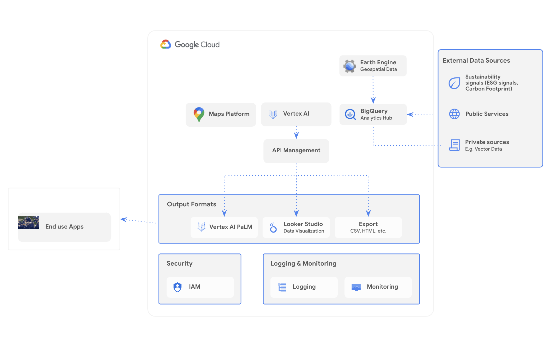
Example architecture of Geospatial Analytics on Google Cloud
Google’s geospatial analysis tools enable a data infrastructure with three fundamental characteristics:
- Data harmonization - Geospatial data comes in many shapes, sizes, and formats; it’s created and updated by a large number of custodians like NASA, the ESA, local governments, and commercial entities. Combining datasets is where we can get a lot of value, but harmonizing disparate datasets is a data engineering challenge.
- Scalable computational power - Many tasks, for example removing clouds from satellite imagery, are repeatable, but computationally intensive. Scaling these types of computation and analysis tasks with high performance — think about the difference between a small grid vs. a country, region, or the world — requires optimized and well-managed compute resources.
- Seamless integration with AI - Analysis is most valuable when it induces action, and AI can play a meaningful role in predicting outcomes and suggesting next steps. To get the most out of geospatial data, it should be fast and easy to start making predictions and take action.
These three capabilities form the backbone of our suite of geospatial and sustainability analytics tools.
Geospational analysis in action
For the past several years, we’ve been working alongside our partners to democratize earth-based data in Google Earth Engine so that it’s more accessible, usable, and actionable.
Streamlined geospatial integration
Climate Engine, a Google Cloud Ready Sustainability partner, has launched a solution called SpatiaFi. By merging Earth and asset-location data, such as a farmer’s field or a highway, conditions can be monitored and analyzed in near-real time to understand the risks and impacts of climate events like floods or wildfires before, during, and after they occur. With the ability to analyze historical, current, near-term, and future time horizons, SpatiaFi helps organizations assess economic impacts as well as the sustainability and resilience of their operations.
Global weather forecasting with AI
Last month DeepMind shared GraphCast, an AI model for faster and more accurate global weather forecasting. GraphCast can also offer early warnings of extreme weather events, accurately predicting the tracks of cyclones, identify “atmospheric rivers” associated with flood risk, or the onset of extreme temperatures. By enabling greater preparedness, GraphCast has the potential to save lives.
Leveraging LLMs and generative AI
With the explosion of AI this year we’ve seen technology change how we think about sustainability challenges, and the proliferation of tools such as geospatial AI to both screen data quality and verify ESG claims is putting more focus on this important issue.
Generative AI, too, is transforming the analytics landscape, enabling users of all technical abilities to navigate complex data. CARTO, in particular, improves the accessibility of geospatial data with conversational GIS, allowing users of all levels to replace complex analytics workflows with dialogue.
Help conserve the natural world with geospatial data
With the ever-growing amount of geospatial data, manual analysis has become impractical. AI can help us analyze real-time data and identify patterns and trends to mitigate certain scenarios, making it easier to assess climate risks across your business and value chain.
Overall, there are many opportunities for AI and ML, but we need to leverage all of the tools under the data-science umbrella to accelerate the needed transformation. To get started mitigating risk to the nature with geospatial and generative AI, consider these three steps:
- Review your data and identify opportunities for geospatial analysis to unlock new insights.
- Harness generative AI to explore new opportunities with conversational geographic information systems across business practices and workflows
- View the Google Earth Engine public catalog to see what data is already available.
We’ll be blogging throughout COP28; follow along here.