Talk to the map: How CARTO is making GIS more conversational using BigQuery
Javier de la Torre
Founder, CARTO
Denise Pearl
Global GTM Practice Lead, Sustainability, Google Cloud
Editor’s note: The post is part of a series showcasing our partners, and their solutions, that are Built with BigQuery.
For decades, organizations have relied on Geographic Information Systems (GISs) to combine analytics with geospatial data to inform their data-driven strategies. This includes industries like telecommunications, where GISs can determine the optimal locations to deploy infrastructure, or environmental planning, to identify the best places to plant trees for maximum benefit. Even the advertising industry uses GIS to pinpoint the most effective billboard locations for campaigns.
However, while GISs have increased in sophistication, allowing companies to hone in on locations or demographics at a granular level, they have also increased in complexity. Today, the full potential of GISs are only easily available to experts in the field, and most GIS or map applications are usually underused due to their complexity barrier.
With the help of Large Language Models (LLMs) and generative AI, CARTO is enabling organizations to overcome this accessibility challenge with Conversational GIS – allowing users of all levels to replace complex analytics workflows with dialogue.
The complexity of GISs, map applications, and portals prevents many users from taking full advantage of their potential. The UI for these traditional apps and systems have a multitude of options and layers to perform analysis, which means that while the capabilities are strong, they can only be accessed by experts trained to navigate the complex analytics workflows.
A second challenge to these applications is the need to run on specific geospatial software separated from the rest of the analytics stack. Solutions that aren’t cloud native typically require duplicating or caching the data in a separate system – which leads to more complex architecture with limited data governance and higher costs. A way to overcome this is by running geospatial analytics in the same cloud-native platform as the rest of the organization.
Simplifying GIS with LLMs and Generative AI
Generative AI is transforming the analytics landscape, enabling users of all technical abilities to navigate complex data with ease. Chat experiences, for example, provide a conversational approach to analytics and allow you to define what they need using only a query or demand – without needing to navigate multiple filters, layers or analytics workflows.
Seeing the benefit of LLMs and generative AI, CARTO has been able to solve the complexity problem of apps and portals and provide a much simpler GIS interface by removing the need for manually selecting filters, options, and other components that stand in the way of GIS functionality. With Conversational GIS, you can simply ask the system about the best locations for your needs. For example: “what locations in my city get the most foot traffic in July?” or “where should I place an advertisement targeting new parents?” Conversational GIS will help you select the best filters for your specific questions – acting as an expert geographer by your side. Not only will you get a simpler, more streamlined experience but you will extract more value from your GIS and get more thorough answers to your questions.
Optimizing campaigns with Conversational GIS
One organization taking advantage of Conversational GIS is Clear Channel Outdoor, a media company at the forefront of driving innovation in the out-of-home (OOH) advertising industry. Clear Channel operates in 21 countries and manages more than 470,000 billboards around the world.
When it comes to building an effective advertising campaign with OOH, the key is aligning the audience with location analysis. It’s important to identify the right locations where your target audience will see them, making sure your advertisements are optimized to reach people at the right times, in the right moments, and at the point of decision during their customer journey.
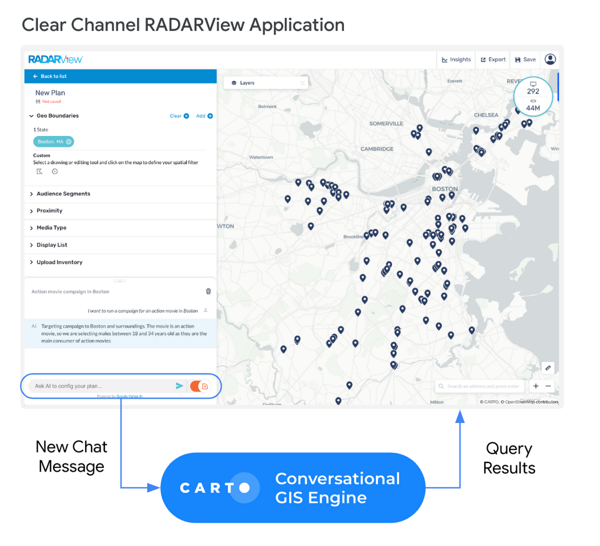
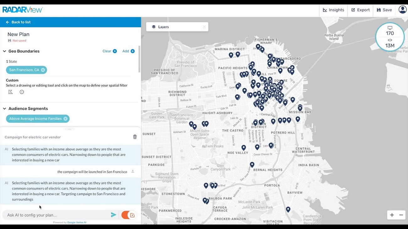
Clear Channel Outdoor’s RADARView is an audience insights platform that has a map-based interface, built on Carto, that combines aggregated demographic data, behavioral insights, and location and proximity targeting to easily discover and select the out-of-home inventory that most efficiently delivers an Advertiser and Brands desired audience.
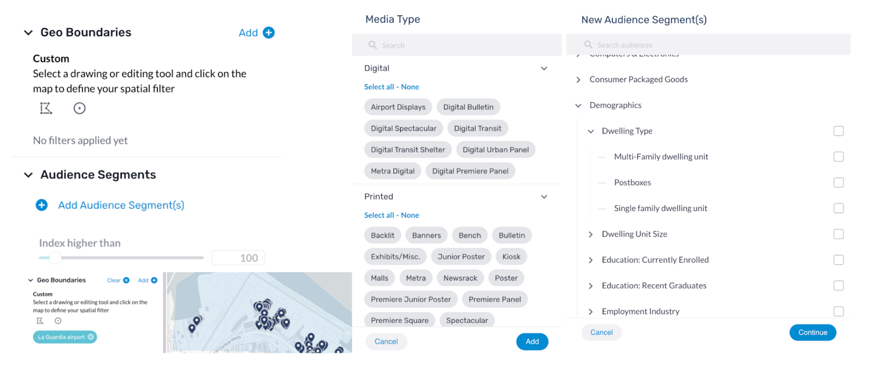
Using RADARView, Clear Channel Outdoor builds OOH media plans using many options that unlock the right combination of behavioral audience data, demographic information, location proximity to a wide range of points of interest to generate the best OOH audience-based campaign. However, with more than 70,000 options (regions, audience segments, brands, etc.) to choose from, there are millions of possible combinations, and choosing the right filters for a campaign is highly complicated. This means the full functionality is only accessible to a team of experts trained on how to optimize the platform. When Generative AI capability is added to RADARView, the product will be easier to use, helping Clear Channel Outdoor’s employees and customers work with data more efficiently to plan OOH campaigns.
By applying CARTO’s Conversational GIS to Clear Channel Outdoor’s RADAR tool, there’s a more natural way of uncovering the right context and audience for an OOH campaign. Now, users of RADARView can have a conversation with the product to build even more successful OOH campaigns. This self-service approach, based on natural language processing and conversation, is expected to increase utilization of the tool among all teams at Clear Channel Outdoor, because the enhancement of semantic navigation of filters simultaneously simplifies the user experience while maximizing the effectiveness of the media plans that are generated, resulting in a very improved and high performing OOH audience-based campaigns – a real win-win.
Built with BigQuery: unlocking the power of geospatial data with generative AI
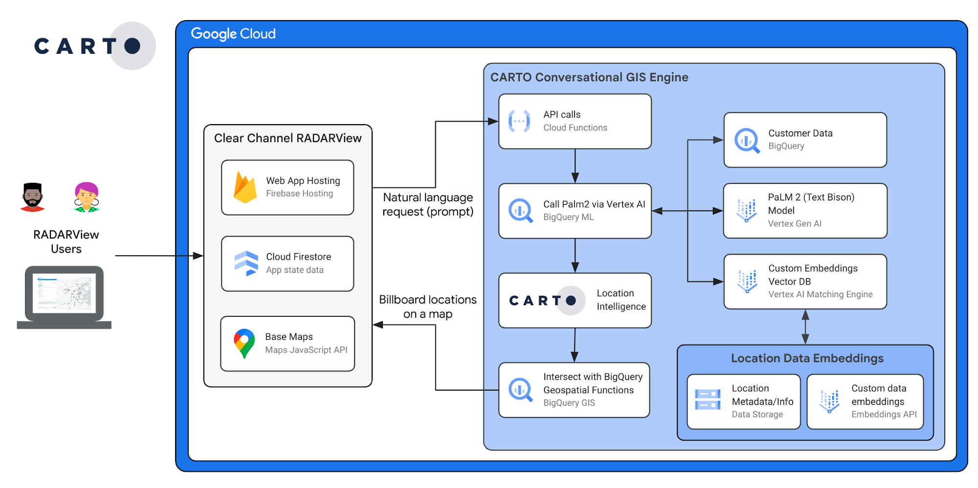
Clear Channel is just one example of Conversational GIS being underpinned by BigQuery and Vertex AI – as well as a range of other Google Cloud services. BigQuery provides the foundation for all the information the generative AI will need, while BigQueryML connects to Vertex AI and PaLM2. Here’s how it works:
When you type in a request or prompt, this query goes to an endpoint in Cloud Functions that calls the PaLM2 model by using the BigQuery ML function ML.GENERATE_TEXT to extract the key entities in the request or prompt
These entities are converted into embeddings, then used to retrieve custom data like audiences, Points of Interest (POIs), brands, and more, all stored in an embeddings database in Vertex AI Matching Engine.
Once the application has the response from the PaLM2 model and the custom data, the application will transform all of these filters into a set of queries that run directly to BigQuery through CARTO.
The final output is a set of billboards in a map that satisfies the filters. The application itself is deployed by using Firebase Hosting and Firestore and it uses Google Maps as basemaps.
Building Conversational GIS not only requires a solid data foundation, scalable systems, and modern data stack architecture, for security, it’s also important that the data never leaves the data warehouse. The combination of CARTO, BigQuery and Vertex AI uniquely provides the capability of LLMs and native geospatial data, all within the same system.
With the addition of geospatial support to BigQuery, and the CARTO platform on top, it is now possible to provide full GIS capabilities in the same analytics platform as the rest of the organization. This makes GIS scalable, cost effective and secure – with no need to move data to any specialized systems, simply run it on the Data Cloud.
CARTO and BigQuery to modernize your GIS application
CARTO enables full GIS capabilities on top of BigQuery native GEO support. This cloud-native architecture avoids having to duplicate your geospatial data to a different system and connects it to the rest of the analytics world. This modern stack results in a more scalable, powerful and cost-effective platform. Learn more about CARTO’s advanced spatial capabilities for BigQuery users here. And if you are interested in how AI can modernize and improve the value of your GIS system, contact one of our experts to guide you.
The Built with BigQuery advantage for ISVs and Data Providers
Google is helping companies like CARTO build innovative applications on Google’s data cloud with simplified access to technology, helpful and dedicated engineering support, and joint go-to-market programs through the Built with BigQuery initiative. Participating companies can:
Accelerate product design and architecture through access to designated experts who can provide insight into key use cases, architectural patterns, and best practices.
Amplify success with joint marketing programs to drive awareness, generate demand, and increase adoption.
BigQuery gives ISVs the advantage of a powerful, highly scalable data warehouse that’s integrated with Google Cloud’s open, secure, sustainable platform. And with a huge partner ecosystem and support for multi-cloud, open source tools and APIs, Google provides technology companies the portability and extensibility they need to avoid data lock-in.
Click here to learn more about Built with BigQuery.