On Water Day, a new tool for sustainable management of precious water resources
Robyn Grimm
Interim Director, OpenET Inc.
Rachel O'Connor
Manager, Climate Resilient Water Systems, EDF
Try Google Cloud
Start building on Google Cloud with $300 in free credits and 20+ always free products.
Free trialEditor's note: At Google Cloud we’re working with global organizations to help them use technology to build a more sustainable future. During the 2022 United Nations Climate Change Conference, or COP27, representatives from countries and organizations around the world — including Google Cloud — gathered in Sharm El-Sheikh, Egypt from November 7 - 18, 2022 for the latest round of climate talks. Check here for perspectives from onsite, thoughts from Google experts and customers, curated content and announcements. Or catch the event for yourself on Youtube.
Managing water resources in a sustainable manner is a challenge on a local to international scale, and is hindered by a lack of detailed data on how water is used across the landscape. Regions susceptible to drought throughout the globe, such as the Horn of Africa or the western United States, are experiencing historic challenges. As a specific example, the Colorado River Basin in the US has been in a 23-year megadrought, dropping the Colorado River and the reservoirs along it to critically low levels. The 2,300-kilometer river serves 40 million people, 2.2 million hectares of irrigated land, and is an important cultural resource to dozens of tribes. As climate change bears down on the Basin, delivering critical data to the hands of farmers, water managers, and government agencies has never been more important.
A new data tool, OpenET, is utilized by stakeholders across the drought-stricken Colorado River Basin to access critical water data and adapt to climate change impacts.
OpenET is an online platform powered in part by Google Earth Engine, and is used across sectors to increase climate change resilience and inform more sustainable water management decisions from the field to the basin. This platform provides publicly accessible evapotranspiration (ET) data — a measure of the amount of water consumed by plants as they grow — at a scale of 30x30m.
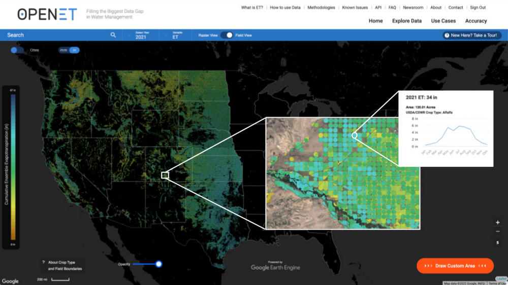
Accurate, timely, and publicly accessible ET data is direly needed to support efforts across the Colorado River Basin to address current water shortages and build a more climate resilient future. The platform is already being used locally to help facilitate the transition to a smaller water footprint that allows farmers to continue growing crops and preserves rural agricultural economies.
For example, on a ranch in Colorado, a multi-year collaborative research project is underway to evaluate the potential water conservation and agronomic viability of temporary and compensated irrigation reductions. Data from OpenET will help the team compare water savings on fields with reduced irrigation relative to parcels with regular irrigation. The project will answer questions about how variations in forage species, soil, and groundwater conditions affect changes in consumptive water use and crop yields when irrigation decreases. Conservation efforts like these will be vital as climate change continues to drive water scarcity in the Basin.
OpenET data can also help illuminate large-scale changes in water demand and use, enabling agencies and water managers to more quickly adapt management practices to current conditions and make better-informed decisions. In the Upper Basin, state and federal agencies have been using ET data for decades to track how much water is consumed annually and inform decision-making on river management. Previously, these agencies used different and sometimes outdated methods to estimate water use that produced incompatible results, making it challenging for water managers and decision-makers to agree about the realities on the ground and effectively use the data across states.
After a nine-year-study, the agencies adopted a satellite-based method that has been made broadly available via the OpenET platform — eeMETRIC — as the standard for measuring evapotranspiration and agricultural consumptive water use across the Upper Colorado River Basin.
Flows in the Colorado River have declined by nearly 20% in the past two decades, and climate change is expected to reduce flows by an additional 10 to 40%. In basins across the world, successful adaptation to the changing climate will require more publicly accessible data and tools that foster collaborative decision-making across sectors at the accelerated pace necessary to meet the moment. Satellite data and cloud-based tools like OpenET are stepping in to meet that demand.
Tyler Erickson, Developer Advocate, Earth Engine, Google, also contributed to this post.